What it does
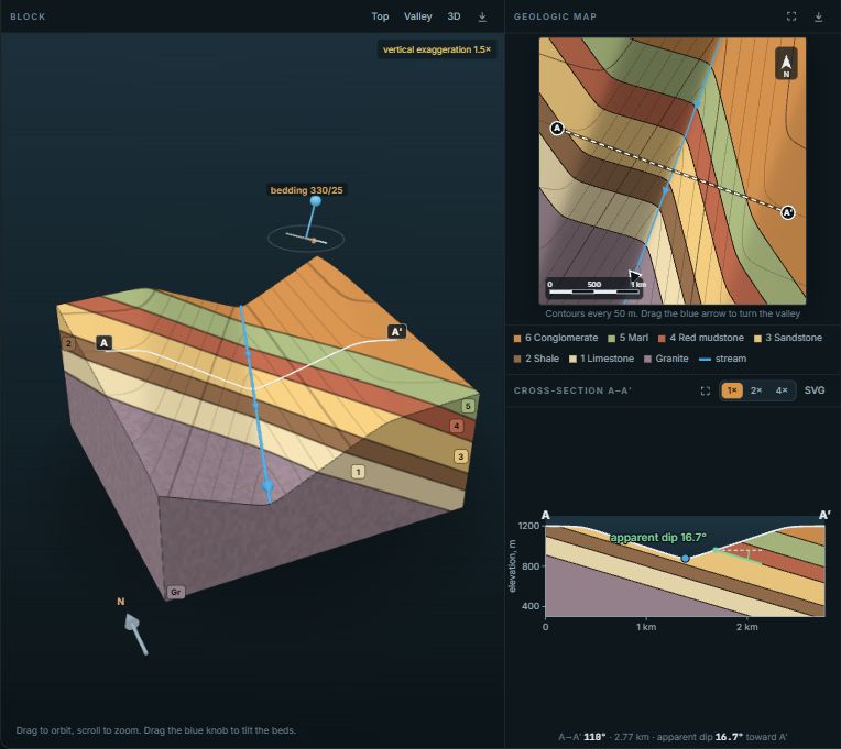
The block is 3 km on a side and drawn at true scale, with no vertical exaggeration. Inside it is one sequence of two to six rock units that you choose, each with its own thickness. The beds can lie horizontal, form a homocline tilted to any strike and dip, or fold into an anticline, a syncline or a fold pair whose axis can be level, plunge one way or plunge both ways. Any of these can be cut by a normal, reverse or strike-slip fault of any dip down to flat, with its slip set as an amount and the fault plane shown, if you like, through the rock erosion has removed. One stream crosses the top to start. Take it away and the whole upland is worn down from the top, the strong beds left standing as ridges; add a second and it is placed for you, in a parallel valley, as a tributary joining the first at a confluence, as a second channel splitting from it, or flowing away from it from a drainage divide. For each stream you set which way it flows, where it runs, how steeply its bed falls and how much it meanders, and for both how deep they have cut and how wide their valleys grow, from narrow canyons to open valleys. The land surface is then worked out from the rock: every face of the block is colored by the unit there, so the contacts on the top are the outcrop pattern of a geologic map.
Beside the block are the map, with 20 m contours, and sections, each saved as a PNG with one click. A start-to-end section runs in a straight line from a stream's start to its end; along a meandering stream it cuts through the meander spurs, so it shows their topography. A channel section follows the stream through its bends, with distance along the river across the bottom, so the contacts tilt one way and then the other as each bend swings across or along the strike: the apparent dip changes from bend to bend. An across section cuts through every valley. All three come from one model of the rock and the land, so they always agree.
Things to try
- Press Uniform to differential. The landscape starts with every rock weathering alike, the plain V-shaped valleys of the textbook, and then each rock takes on its own rate. Watch the strong beds rise into ridges and the valleys narrow where they cross them.
- Press Play the erosion. The streams cut down from the flat upland and the slopes wear back as they go. The strong beds hold up the land longest.
- In Rule of Vs mode, step through the presets. Each turns the beds against stream 1: horizontal, dipping upstream, vertical, dipping downstream more or less steeply than the stream, and striking along it. The section switches to run down the stream, where the reason shows.
- Make a stream meander and open the Channel section. The apparent dip of the beds changes round every bend, and the channel itself falls more gently than its valley, because its winding course is longer.
- Try the Divide layout. The two streams flow in opposite directions across the same beds, so one can V upstream while the other Vs downstream. The panel gives the verdict for each.
- Make one stream pirate the other. Add a second stream and turn it into the first, or move the two close together and raise their sinuosity until the meanders meet. Where they meet, the one cutting lower captures the other: the captured stream's lower course disappears and its upper course is regraded to join its captor at the same level.
- Choose Anticline. Erosion breaches the crest: the oldest rocks crop out along the axis, ringed by ridges of the strong beds, and a stream crossing the fold meets beds dipping upstream on one limb and downstream on the other, so its Vs turn round at the axis. Syncline and Fold pair show the opposite and the repeat.
- Turn on a fault and try Normal, Reverse and Strike-slip. Where the fault puts strong rock against weak, erosion picks out a fault-line scarp; across a normal or reverse fault the outcrop bands drop out or repeat, and across a strike-slip fault they are offset sideways.
- Open the type examples in the Rule of Vs tab. The Grand Canyon's flat-lying cliffs and slopes, the breached, doubly plunging Sheep Mountain anticline with a river cutting straight through it, and Siccar Point, where steep graywackes are cut off by an angular unconformity beneath gently dipping Old Red Sandstone.
- Make an anticline plunge both ways. The fold closes at both ends and the outcrop bands wrap round into an elongated oval, like an eroded dome; a doubly plunging syncline makes the basin version.
- Switch the climate to humid with a limestone in the sequence. The limestone goes from cliff former to valley former, and the map changes with it.
The rule of Vs, in rock that weathers unevenly
Where a contact crosses a stream valley its outcrop bends into a V. For a stream falling at gradient g across beds whose apparent dip along the stream is a (positive downstream), the V points upstream unless a is greater than g. Horizontal beds V upstream exactly as the contours do; beds dipping upstream V upstream, less far than the contours; beds dipping downstream more gently than the stream V upstream further than the contours; vertical beds cross straight. All of this holds whatever the rocks are, because it depends only on where the bed and the valley floor meet.
Differential weathering changes the valley, not the rule. A strong bed wears back slowly, so where a stream crosses it the valley walls are steep and close together and the V of its contacts is tight. A weak bed wears back fast, its valley opens out, and the V spreads wide. Between the valleys the strong beds stand above the weak ones, so the outcrop pattern zigzags across ridges and valleys alike. Beds dipping downstream steeply leave the strong layers as triangular flatirons on the dip slope, each one pointing upstream between two valleys.
On the map, read the strong beds from the contours. Where a cliff former crops out the contours crowd together and its outcrop band stays narrow; a slope former spreads across wide, gently sloping ground with the contours far apart. With the contrast at zero the contours are evenly spaced across every unit, and the outcrop widths depend only on the thicknesses and the dip.
How the landscape is made
Each rock is given two angles. The first is the slope it is left at while a stream cuts down through it: the streams cut 1 m for every unit of time, and a slope in that rock wears back 1 / tan of that angle in the same time, so a weak rock retreats several times faster than a strong one. The second is the steepest face the rock can stand before it fails. The block is sliced into levels 4 m apart; each level opens where a stream bed reaches it and the opening spreads sideways at the speed of the rock at that level, but a level cannot open under ground that is still standing above it. Then any face steeper than its rocks can stand is cut back. A face that cuts through several layers needs, for each one, its height divided by the tangent of that rock's angle, so a thin caprock over a thick shale cannot hold a shale wall under it: the shale takes most of the room, and the cap is cut back. That is how a weak bed undermines a strong one. The result is the land after the streams have reached their beds.
The model leaves out much that matters in nature, such as soil, landslides, the streams' own response to hard rock and the time since they stopped cutting down. It keeps the two things that decide what a student sees on a geologic map: strong rocks hold steeper and higher ground than weak ones, and the outcrop of a contact is where the bed meets that ground.
Using it in class
The quiz hides the block and the section. One question shows a map with two valleys and asks which way the beds dip compared with the streams. The other hides the rock colors, numbers the units, and asks which one is the strong bed, to be read from the contours: close together on its cliffs, far apart on the weak slopes.
- Copy link saves the whole setup: the sequence, the bedding, the streams and the view.
- Projector mode fills the screen. Set up a sequence, hide the panel, and ask the class where the ridges will be before you press Play the erosion.
- Embed gives code for Canvas, Moodle or a course page.
The plain rule of Vs, with faults, sections and compass readings, is in the Block Diagram Builder.